ESCAPE MAPS
기술이 보여주는 생경하고 무한한 환영(幻影) 속, 오늘날 미지의 세계는 더 이상 정글이나 사막과 같은 전통적인 탐험 장소가 아닌, 데이터로 묘사되지 않는 공간, 카메라에 건물로, 길로써 인식되지 않는 공간, 정보 없음의 공포성을 띤 공간으로 대체된다. 물리적 공간은 데이터로 번역·전송되어 가상공간에 완벽히 현상되었다고 여겨진다. 데이터를 축적하며 모든 것을 매끈한 시스템으로 다져가고 있는 흐름 속에서도 안내방송과 다른 방향으로 열리는 지하철 문, 막다른 길로 안내하는 내비게이션, 지도 앱에서 계산되지 않는 높낮이 있는 지형들과 같이 ‘어긋난 데이터’들이 현실 세계를 왜곡한다.
디지털 지도의 구성
'정확한' 현실을 지도에 구현하기 위해 현실의 불확실성은 어떻게 처리되고 있을까. 일시적인 환경은 시간과 효율성을 변수로 업데이트되고, 미처 파악하지 못한 데이터의 사각지대는 플랫폼 생태계의 경계 속에서 자발적으로 공유된 데이터(리뷰, 사진, 피드백 등)를 통해 현실과 동기화된다. 개인들의 플랫폼 노동을 통해 공유된 데이터 일부는 불투명한 기준으로 탈락한다. 이미지만으로 만들어진 세계 속에서 경험은 완벽히 통제가 가능해지고, 현실은 여러번 시뮬레이션된다. 완벽한 디지털 지도를 구성하는 과정에서 가치를 부여받지 못하고 탈락한 데이터들, 관점들과 그 속의 사건들을 함께 살펴본다. 어디까지가 승인되고 탈락하는 데이터일까?
1. 탈락된 데이터
a. 기계학습과 지도 업데이트
b. 위치와 방향성개선을 위해 선택, 탈락된 데이터들
- "That's why a core ingredient in this new approach is applying machine learning to automatically decide which features to pay attention to, prioritizing features that are likely to be permanent parts of the scene and ignoring things like trees, dynamic light movement, and construction that are likely transient. This is just one of the many ways in which we use machine learning to improve accuracy."
c. 스트리트뷰에서 제거된 독일의 집들에 대한 댓글 의견 과 스크라이 샌드 효과
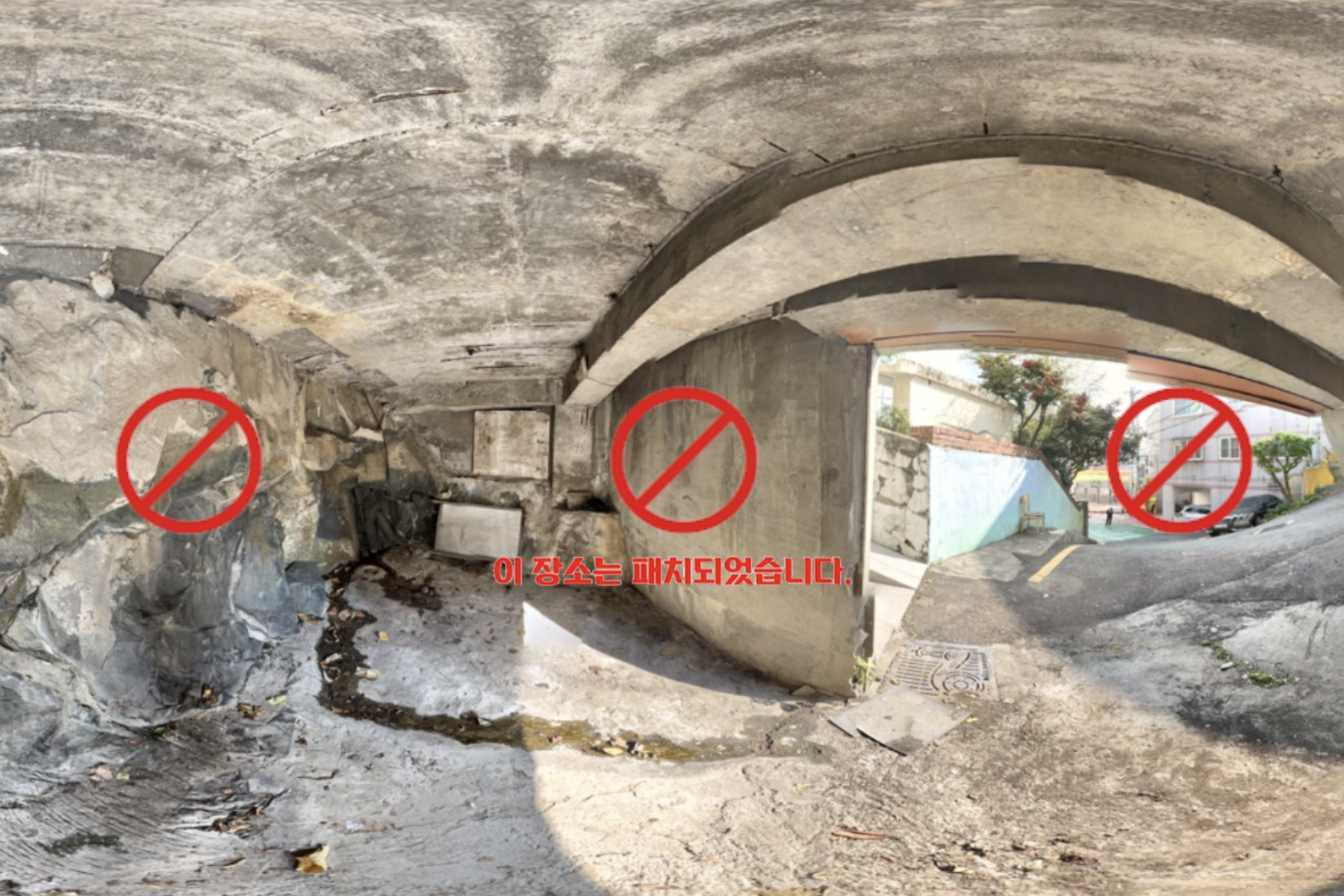
d. 구글 지역 가이드 유저가 제공한 밤의 스트리트뷰는 삭제되었습니다
2. 어긋난 데이터
a. 트랩 스트리트
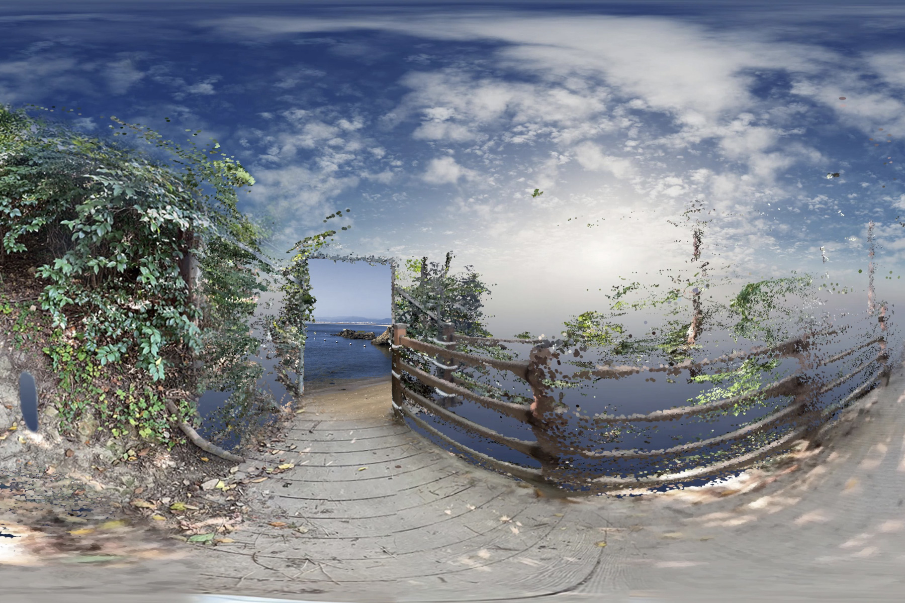
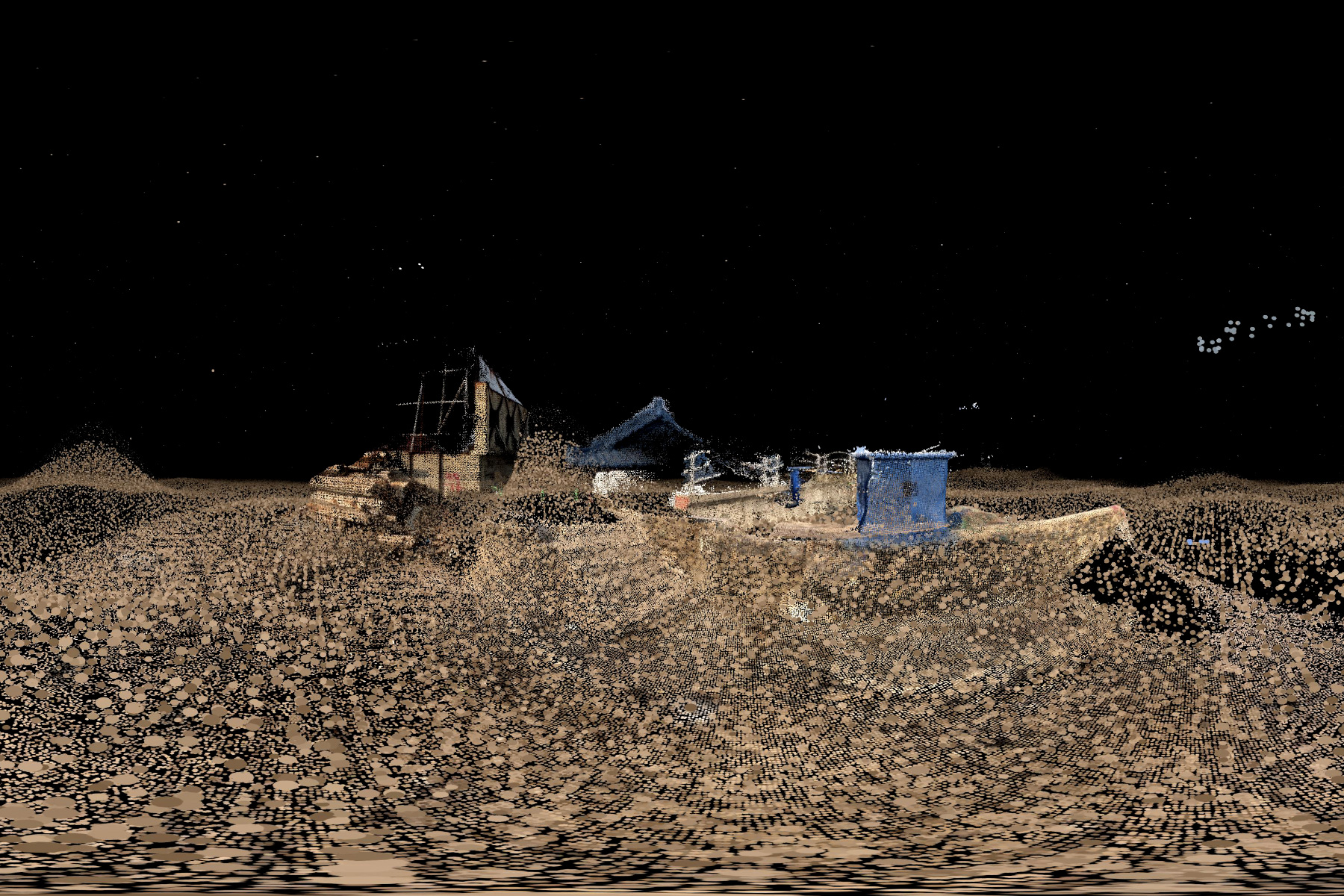
[Image Caption] 맵탈출 투어 여행사(2021) 작업을 위해 업로드한 어긋난 스트리트뷰 이미지. 공간의 시공간적 데이터를 포함하며, '사실그대로, 있는 그대로 보여지는' 3D 공간 스캐닝 기술, 다각도에서 촬영한 사진 데이터를 분석 후 3D 모델과 공간으로 생성해주는 서비스들을 이용해 현실을 복제한다.
가상현실과 역재현
선별되고 해석된 데이터를 바탕으로 현실이 다시 재현되기 시작한다. 가상현실로서의 디지털 지도와 그곳에 담긴 새로운 욕망들. 아날로그 지도의 제작, 표현방식에서 제작 목적과 그 시대의 인식을 알 수 있는 것과 같이, 현재의 디지털 지도와 연결된 사건들을 깊이 들여다보며 그 속에서 중요하게, 반복적으로 다뤄지는 것, 복합적인 위치에서 서로 얽혀있는 동시대의 관점들을 이끌어낸다. 가상의 '맵'에서 발생한 새로운 룰(Rule)이 다시 현실에 적용될 수 있는가 혹은 어떻게 적용되고 있는가. '완벽한 현실'은 어떻게 현실에서 분리되는가.
1. 디지털 지도와 얽힌 사건들
a. 기억의 부속물로서의 스트리트뷰와 통제할 수 없는 기록됨
b. 코스타리카와 니카라과 분쟁의 중심에서
c. 가파르고 위험한 Baxter Street로 안내하는 지도
d. 점점 완화되는 인공위성 촬영 해상도
e. What Spatial Resolution Is Enough?
2. 디지털 지도의 역재현
a. 기계학습을 통해 '빅데이터'가 되는 스트리트뷰 이미지
b. 스트리트뷰 속 자동차로부터 추정되는 인구통계의 활용
c. 거리수준의 환경인식과 그린캐노피 인식 개선
맵탈출과 해킹문화
게임 맵 밖으로 탈출하기 위해 실제 유저들은 게임이 제시하는 본래의 목적(미션)을 뒤로하고, 대각선으로 걷기, 공간 사이 틈에 끼이기 등 게임속 버그를 활용해 주어진 조건을 축소, 증폭하며 게임의 구성 방식을 탐색하고 미지의 공간을 점유한다.
게임 속 공간을 자발적으로 탐색하는 맵 탈출 놀이를 통해 아직 디지털 지도에 데이터화되지 않은 물리적 공간들을 탐험하고, 플랫폼 방식을 오용하여 디지털 지도와 가상 공간을 해킹한다. 현실을 복제, 번역하며 새로이 구축되는 가상공간에 대한 개념을 탐색해 나가는 현재, 선별되지 못하는 순간적이고 유동적인 모습들을 가상공간에 업로드하고, 비가시적인 필터링을 통해 탈락된 데이터에 대한 화두를 던지면서 탈락된 것들이 사실 무엇으로부터의 탈락인지 다시 생각해본다.
2021년 여름, 흩날리는 모래사장. 부산에서 레지던스 기간 중 구글 스트리트뷰 가이드라인에 맞추되 보편적 기대와 어긋난 스트리트뷰를 제작, 업로드했다. 5개월이 지난 현 시점(2022.04), 업로드한 6개의 스트리트뷰 중 하나는 현재의 구글맵에서 보이지 않게 되었다. 업로드된 이미지 중 가장 현실과 닮은 이미지였지만 하늘이 어두워 밤으로 분류되었을 것으로 추측된다.
Related Works
Map Escape Tour Agency, 2021Map Escape Tour, 2022
Map Escape Tour: The Phantom, 2023
Within the unfamiliar and infinite phantasm (幻影) presented by technology, the unknown world today is no longer a traditional place of exploration like a jungle or a desert. Instead, it is replaced by spaces not depicted by data, spaces not recognized by the camera as a building or a road, and spaces carrying the terror of information deficit. Physical space is believed to have been perfectly realized in virtual space, translated and transmitted as data. Even in the current trend of accumulating data and refining everything into a seamless system, 'deviant data'—such as a subway door opening on the opposite side to the announcement, navigation guiding to a dead end, or unrecognized uneven terrains—distort the real world.
The Composition of Digital Maps
How is the uncertainty of reality handled to implement an 'accurate' reality on the map? Transient environments are updated with time and efficiency as variables and blind spots in the data that are not fully understood are synchronized with reality through voluntarily shared data (reviews, photos, feedback, etc.) within the platform ecosystem's boundaries. A portion of the data shared through individuals' platform labor is excluded based on opaque criteria. In this world made only of images, experience becomes perfectly controllable, and reality is simulated multiple times. We examine the data that failed to be valued and was excluded during the process of constructing the perfect digital map, along with the diverse perspectives and events contained within them. Where is the line between data that is approved and data that is rejected?
1. Excluded Data
a. Machine Learning and Map Updates
b. Data selected and excluded to improve location and directionality:
- "That's why a core ingredient in this new approach is applying machine learning to automatically decide which features to pay attention to, prioritizing features that are likely to be permanent parts of the scene and ignoring things like trees, dynamic light movement, and construction that are likely transient. This is just one of the many ways in which we use machine learning to improve accuracy."
c. Commentary on German houses removed from Street View and the Streisand Effect
d. Nighttime Street View provided by a Google Local Guide user was deleted.
2. Deviant Data
a. Trap Streets
[Image Caption] Aberrant Street View image uploaded for the Map Escape Tour Agency (2021) artwork. It incorporates the spatiotemporal data of the space and uses 3D space scanning technologies that are 'shown as they truly are' and services that analyze photographic data taken from multiple angles to create 3D models and spaces, thereby duplicating reality.
Virtual Reality and Counter-Representation
Reality begins to be re-represented based on selected and interpreted data. Digital maps as virtual reality and the new desires contained within them. Just as the purpose of creation and the perspective on the contemporary era can be observed in the production and expression methods of analog maps, we delve deeply into events related to current digital maps to draw out what is treated as important and recurring, as well as contemporary perspectives intertwined in complex positions. Can a new Rule generated in the virtual 'map' be reapplied to reality, or how is it being applied? How is 'perfect reality' separated from reality?
1. Events Intertwined with Digital Maps
a. Street View as an accessory to memory and the uncontrollable nature of being recorded
b. At the center of the conflict between Costa Rica and Nicaragua
c. The map guiding to the steep and dangerous Baxter Street
d. The gradually relaxed resolution of satellite photography
e. What Spatial Resolution Is Enough?
2. Counter-Representation of Digital Maps
a. Street View images becoming 'Big Data' through machine learning
b. Utilization of demographics estimated from cars in Street View
c. Improved environment perception at the street level and green canopy recognition
The Future of Mapping Might Be the Past of Gaming
Just as we find our way and information through real-world maps, maps play a crucial role in games for players to navigate virtual terrain and achieve goals. How are maps utilized in games? Games like Euro Truck Simulator, GTA, and Flight Simulator, which meticulously implement real-world spaces, utilize actual geographic information and map data to reproduce road networks, urban structures, and airports in detail. While games sometimes utilize digital map information, a recent trend is the reverse: attempts to use games to train autonomous driving. Open-world games like GTA, in particular, with their realistic traffic situations and road conditions, become an alternative to real driving data, offering a cost-effective environment for learning autonomous driving technology. Scenarios can be repeatedly experimented with within the virtual environment of the game.Map Escape and Hacking Culture
To escape the game map, users—forsaking the game's original objective (mission)—utilize in-game bugs such as walking diagonally or getting stuck in gaps between spaces. They shrink or amplify the given conditions, exploring the composition of the game and occupying unknown spaces.
Through 'map escape' play, which involves voluntarily exploring spaces within the game, we explore physical spaces that have not yet been digitized on digital maps, and hack the digital map and virtual space by misusing platform mechanisms. In the present, where the concept of virtual space—replicated and newly constructed through the translation of reality—is being explored, we upload momentary and fluid aspects that cannot be selected and raise the issue of data excluded by invisible filtering. This leads us to rethink what exactly those excluded elements are excluded from.
[Image Caption] Summer 2021, scattering sand. During a residency in Busan, we produced and uploaded Street View images that adhered to Google Street View guidelines but deviated from common expectations. As of the current moment (April 2022), five months later, one of the six uploaded Street View images is no longer visible on Google Maps. We suspect it was classified as a night image because the sky was dark, even though it was the most realistic of the uploaded images.
Related Works
Map Escape Tour Agency, 2021Map Escape Tour, 2022
Map Escape Tour: The Phantom, 2023